Overhead Lines or Buried Cables? Two Ways to Carry Electricity
Compare overhead lines or buried cables by visibility, land use, construction access, and terrain to ask clearer questions about a proposed electricity route.
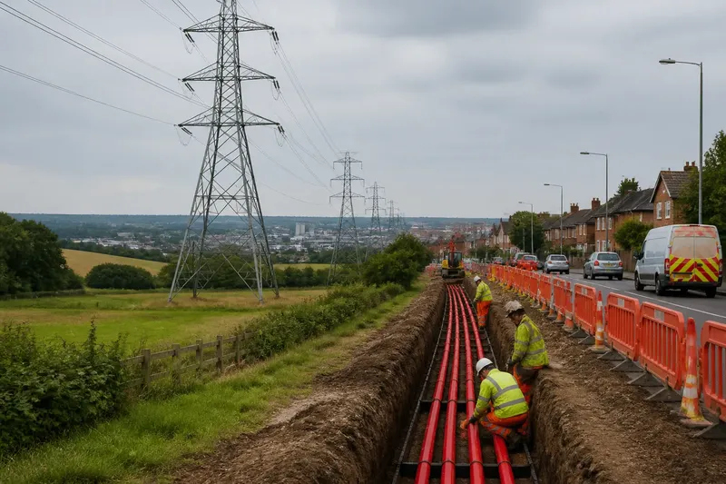
On a walk beside a park, steel towers can make an electricity route impossible to miss. A few blocks away, cables may run below a busy street, out of sight until crews need to reach them. Comparing overhead lines or buried cables means looking beyond appearance to the land each route occupies and the work needed to build and maintain it.
Start with the route’s endpoints and purpose
A transmission route carries electricity between major parts of the grid, such as generating stations, substations, and other network connections. It differs from the neighborhood wires that serve local streets, though both transmission and distribution equipment can be overhead or underground.
Locate the route’s endpoints, then follow the land between them. A path across open farmland faces different constraints from one through a dense city, wooded corridor, or area where road and rail crossings leave little room.
The route includes more than the visible wire or buried cable. Overhead lines need towers or poles, clearance, and access. Underground systems need buried cables, access points, and supporting equipment that may sit in buildings or at the surface. Compare the complete arrangement, not just whether one section is hidden.
Compare visibility and the space each route uses
Overhead lines are conspicuous. Towers and conductors can be seen across fields or above roads, changing how people experience a landscape. Underground cables reduce that visual presence along the buried section, but substations, access structures, and construction activity may still be visible.
Overhead routes need a corridor that keeps structures and conductors clear of surrounding activity. Vegetation management and maintenance access are part of that arrangement. A buried route avoids a line of towers along the cable section, but the land above and around it may still have limits on excavation, planting, or construction. The details depend on the route and local arrangements.
Existing land use matters. A clear corridor across open land may accommodate towers more readily than a crowded urban street. In a built-up area, burial may reduce a visual obstacle, while excavation can compete with roads, foundations, water pipes, and other utilities. Neither method takes up no space; each uses it differently.
Consider how crews can inspect and repair the route
Overhead equipment is generally visible from the ground, which can help crews identify where a problem may lie. Reaching a tower or line may still require safe access across land, specialized equipment, and suitable conditions. Trees, storms, ice, and other local hazards can shape maintenance needs.
Buried cables are shielded from direct exposure to some surface conditions, but their location makes inspection less straightforward. Crews may need to narrow down a fault’s position and reach the cable, sometimes by opening pavement or ground. That work can disrupt traffic or other land uses while repairs are underway.
For either route, ask where vehicles can enter, what landowners or road authorities must coordinate, and how crews would stage work in a busy corridor. These concrete questions clarify access needs without assuming that one construction method is always easier to maintain.
Follow terrain and existing infrastructure along the route
Overhead routes must account for obstacles and exposure above ground. A path through a forest may need careful clearance; a route over roads, rivers, or developed areas must cross those features safely. Terrain also affects where towers can stand and how crews reach them.
Underground routes face different physical constraints. Soil, rock, groundwater, existing utilities, and the availability of a workable cable path can all matter. At crossings or in congested areas, finding space below ground may be difficult even when the surface seems suitable.
Some routes use different approaches in different sections. A river crossing, crowded street, or sensitive view may change the local trade-offs. Follow the route segment by segment instead of assuming that one answer fits its entire length.
What should you ask about a proposed route?
Why are overhead lines easier to see?
The conductors sit above ground on towers or poles, making the route visible across much of its length. Structures also need clear space around them, so the corridor may remain noticeable even where the wires are less apparent.
Does burying a cable remove all surface disruption?
No. Installation and repair can involve excavation, and access structures or substations may remain visible. The buried section is less prominent, but land above it may still have limits on digging or building.
Which route is easier for crews to repair?
It depends on the fault, terrain, and available access. Overhead equipment can be seen from the ground, while a buried cable fault may require crews to locate and reach a point below ground; either route can present difficult site conditions.
Can one project use both approaches?
Yes. A route may use overhead lines where a corridor is available and buried cables where a local constraint favors that approach. Transition points and their supporting equipment also need space and planning.
Use a route walk-through to frame useful questions
Say a proposed connection runs from a substation beside an industrial district toward another substation beyond open fields. For this invented example, assume the starting route map shows a crowded road corridor with several marked utilities, followed by open land with a possible overhead corridor. First, note that the road section has competing underground uses; then ask the project team to confirm utility locations and explain how excavation and traffic access would be managed. Next, mark the open stretch for review of tower locations, visibility, and maintenance entry. The resulting comparison does not select a design, but it identifies distinct questions for each section and makes a mixed approach a topic to evaluate rather than an assumption.
As you review a route map or walk accessible public areas, record observations and let each one guide a follow-up decision:
- Visibility: Check for homes, parks, and viewpoints near the route; if towers would be conspicuous, then ask the project team to compare visual effects and any feasible alternatives, otherwise record that visibility is less prominent and continue checking other constraints.
- Existing utilities: Check maps or project documents for water pipes, sewers, and other services; if underground space is crowded or uncertain, then request utility-location and construction details, otherwise ask how the proposed cable path avoids the services shown.
- Construction access: Check where work vehicles could enter and whether roads or private land are involved; if access needs coordination, then identify the relevant landowner or road authority for the project team to consult, otherwise ask how crews would reach the site using the available route.
- Terrain and crossings: Check for slopes, rivers, rocky areas, and road or rail crossings; if a feature creates a distinct constraint, then ask for a section-specific construction review, otherwise note that the route appears to have fewer visible terrain obstacles.
- Land use above a buried route: Check whether the area is used for planting, excavation, or building; if those activities could conflict with cable restrictions, then ask what limits would apply, otherwise record the current use and ask how future access would be protected.
- Possible method changes: Check whether a local feature differs sharply from the rest of the route; if it creates a clear change in land use, visibility, or access, then ask whether a transition between methods is feasible, otherwise compare the route as one continuous approach.
These observations help frame questions; they do not establish engineering feasibility or replace project documents. The responsible utility and relevant local authorities can explain which site conditions, access arrangements, and rules apply.
Compare the corridor during construction and later use
Overhead lines and buried cables make different demands on land and on the people responsible for operating them. One is more visible and needs clearance above ground; the other reduces visual presence along its buried length but can complicate access to faults and compete for space below ground. Neither description captures every local detail.
When a route is described as “hidden” or “easy to maintain,” ask which section, which task, and under what conditions. A useful comparison of overhead lines or buried cables follows the corridor from end to end, includes the places crews must reach, and considers what neighbors and land users encounter during construction and after the work is complete.